EARTHQUAKES · DAILY

Earthquakes on Friday, September 25, 2026

Complete day, UTC
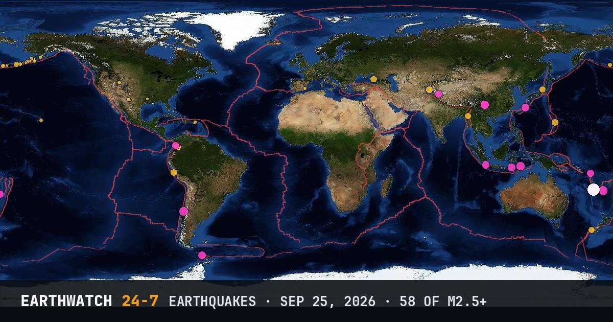
World map of the earthquakes on September 25, 2026

USGS recorded 58 earthquakes of magnitude 2.5 or larger around the world on Friday, September 25, 2026 (UTC). 19 were magnitude 4.5 or stronger, including 1 of magnitude 6 or more. The strongest was a magnitude 6.6 near Tadine, New Caledonia at 21:23 UTC.

Earthquakes M2.5+58
M4.5 and up19
M6 and up1
StrongestM6.6
Deepest483 km
Most activeAlaska
See it on the live 3D globe →Watch live on YouTube🔔 Get alerts near you

Strongest earthquakes

By magnitude

M2.5 – 3.929
M4.0 – 4.920
M5.0 – 5.98
M6.0 and up1

Most active regions

Every earthquake

Time (UTC)MagDepthWhere
00:483.110 km125 km SSE of Sand Point, Alaska
00:574.656 km34 km WSW of Sipí, Colombia
02:134.2124 km36 km SW of Monywa, Burma (Myanmar)
02:253.05 km55 km SSW of Whites City, New Mexico
02:424.210 km30 km SW of Sochi, Russia
03:574.210 km18 km WNW of Chaparral, Colombia
04:262.610 km144 km SE of Akutan, Alaska
04:264.446 km32 km SSW of Huacho, Peru
04:275.010 km124 km N of Metinaro, Timor Leste
05:103.416 km126 km WSW of Adak, Alaska
05:152.918 km8 km WNW of Culebra, Puerto Rico
05:172.748 km98 km SSW of Unalaska, Alaska
05:212.726 km103 km SSW of Unalaska, Alaska
05:354.3213 km52 km NNW of Khandūd, Afghanistan
05:413.10 km3 km NW of Little America, Wyoming
05:572.59 km16 km NE of House, New Mexico
07:184.1167 km6 km E of Kariwa, Japan
07:194.410 km27 km ENE of La Cumbre, Colombia
07:304.2108 km51 km NNW of Te Anau, New Zealand
08:042.835 km98 km S of False Pass, Alaska
09:042.910 km4 km S of Abanilla, Spain
09:322.635 km117 km SSE of Sand Point, Alaska
10:363.257 km86 km SE of Nikolski, Alaska
11:125.324 kmVanuatu region
11:534.510 km72 km E of Thang, India
12:374.910 kmDrake Passage
12:373.823 km136 km SW of Nikolski, Alaska
13:172.58 km6 km SSE of Salinas, Puerto Rico
13:474.710 km71 km SW of Labuan, Indonesia
13:522.835 km108 km SE of Akutan, Alaska
14:303.3124 kmRat Islands, Aleutian Islands, Alaska
15:094.4109 kmPagan region, Northern Mariana Islands
15:122.735 km69 km SE of Adak, Alaska
15:295.219 km69 km SW of San Antonio, Chile
15:552.577 km90 km WSW of Adak, Alaska
17:072.568 km55 km WSW of Karluk, Alaska
17:543.28 km2 km SW of Honaunau-Napoopoo, Hawaii
18:012.66 km11 km NE of Toyah, Texas
18:382.635 km84 km SE of King Cove, Alaska
19:144.714 km36 km ENE of Kunigami, Japan
19:394.814 km42 km N of Ruteng, Indonesia
20:262.76 km9 km NE of Pleasant Hill, Louisiana
20:312.99 km131 km E of Chignik, Alaska
20:414.6224 km144 km SE of Lata, Solomon Islands
20:434.5483 kmsouth of the Fiji Islands
21:015.010 km13 km N of Xunchang, China
21:084.410 km4 km NNE of Qingfu, China
21:213.110 km100 km SE of Nikolski, Alaska
21:236.610 km80 km ENE of Tadine, New Caledonia
21:452.735 km60 km SSE of King Cove, Alaska
22:075.110 km78 km ENE of Tadine, New Caledonia
22:232.583 km21 km WSW of Cantwell, Alaska
22:263.0188 km33 km SSW of Nelson Lagoon, Alaska
22:584.810 km84 km ENE of Tadine, New Caledonia
23:324.910 km78 km NE of Tadine, New Caledonia
23:395.510 km61 km ENE of Tadine, New Caledonia
23:525.410 km69 km ENE of Tadine, New Caledonia
23:575.010 km15 km NNW of Xunchang, China

Data: USGS earthquake catalog, magnitude 2.5 and up, times in UTC. Outside the United States, USGS mainly lists quakes of about magnitude 4 and up, so smaller ones there are undercounted. Magnitudes and locations can be revised.

Did you know?

Most earthquakes are shallow. Most earthquakes start within the top 70 km of the Earth, in the brittle outer shell called the lithosphere.

All daysSep 26 →