EARTHQUAKES · DAILY

Earthquakes on Tuesday, September 29, 2026

Complete day, UTC
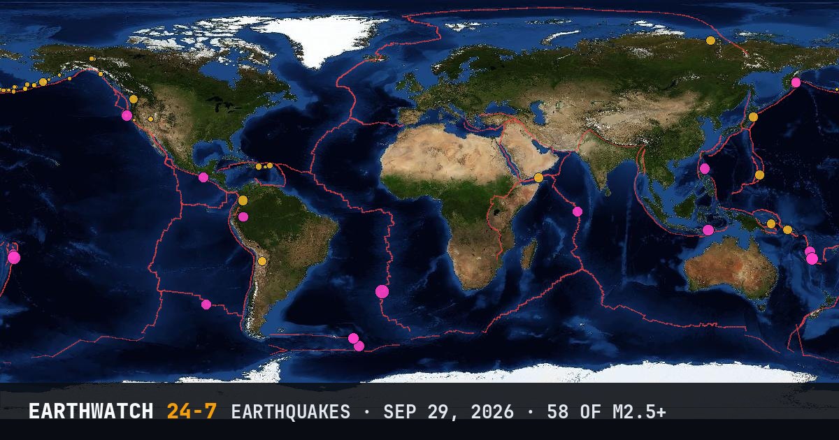
World map of the earthquakes on September 29, 2026

USGS recorded 58 earthquakes of magnitude 2.5 or larger around the world on Tuesday, September 29, 2026 (UTC). 17 were magnitude 4.5 or stronger. The strongest was a magnitude 5.5 in the southern Mid-Atlantic Ridge at 13:06 UTC.

Earthquakes M2.5+58
M4.5 and up17
M6 and up0
StrongestM5.5
Deepest219 km
Most activeAlaska
See it on the live 3D globe →Watch live on YouTube🔔 Get alerts near you

Strongest earthquakes

By magnitude

M2.5 – 3.929
M4.0 – 4.925
M5.0 – 5.94
M6.0 and up0

Most active regions

Every earthquake

Time (UTC)MagDepthWhere
00:054.535 km169 km SE of Atlasovo, Russia
00:114.410 km180 km NNE of Caluula, Somalia
00:442.810 km87 km SSE of Akutan, Alaska
00:472.833 km197 km SE of Chiniak, Alaska
00:553.321 km92 km NE of Cruz Bay, U.S. Virgin Islands
01:052.78 km124 km S of Nikolski, Alaska
01:282.682 km299 km W of Adak, Alaska
01:382.87 km114 km S of Nikolski, Alaska
01:463.4115 km7 km E of La Romana, Dominican Republic
01:472.612 km33 km S of Sand Point, Alaska
02:263.09 km17 km E of Eagle Village, Alaska
03:235.310 km76 km NE of Tadine, New Caledonia
03:472.717 km75 km SE of Unalaska, Alaska
04:142.666 km4 km NNE of Aguas Buenas, Puerto Rico
04:164.835 kmSouth Sandwich Islands region
06:164.437 km102 km E of Miyako, Japan
06:384.835 kmSouth Sandwich Islands region
07:062.531 kmRat Islands, Aleutian Islands, Alaska
08:172.657 km13 km N of Karluk, Alaska
08:214.542 km95 km SSW of Ocós, Guatemala
09:112.616 km74 km SSE of Adak, Alaska
09:503.10 km19 km W of Preston, Nevada
10:142.910 km27 km W of Elfin Cove, Alaska
10:224.5135 km96 km ENE of Alianza Cristiana, Peru
10:244.050 km64 km SE of King Cove, Alaska
10:425.010 km77 km ENE of Tadine, New Caledonia
11:142.524 km74 km SSE of Adak, Alaska
11:274.810 km98 km SW of Port-Vila, Vanuatu
11:364.810 km97 km W of Petrolia, California
12:405.410 km99 km SSE of Pangai, Tonga
13:065.510 kmsouthern Mid-Atlantic Ridge
14:144.9153 km61 km NW of Pante Makasar, Timor Leste
14:342.710 km132 km W of Petrolia, California
14:404.454 km192 km ESE of Mil’kovo, Russia
15:174.8114 kmSouth Sandwich Islands region
15:314.610 kmWest Chile Rise
15:312.573 km5 km E of Perryville, Alaska
16:052.822 km152 km SW of Adak, Alaska
16:062.58 km5 km W of Yountville, California
16:112.628 km83 km SW of Adak, Alaska
16:134.757 km50 km N of Fangale’ounga, Tonga
16:172.668 km227 km WSW of Adak, Alaska
17:242.75 km73 km N of Dawson City, Canada
17:402.7185 km84 km NE of Atka, Alaska
18:194.310 km136 km ESE of Gizo, Solomon Islands
18:214.1167 km101 km NE of San Pedro de Atacama, Chile
18:482.85 km169 km S of Atka, Alaska
19:472.63 km95 km S of Nikolski, Alaska
20:454.710 km48 km N of Dicabisagan, Philippines
21:054.228 km6 km WNW of Wauna, Washington
21:112.8208 km47 km NNE of Atka, Alaska
21:504.410 km13 km SSW of Roncesvalles, Colombia
22:174.610 kmCarlsberg Ridge
22:302.8219 km86 km NNE of Nikolski, Alaska
22:484.310 km106 km SE of Kimbe, Papua New Guinea
23:184.310 km74 km NE of Tadine, New Caledonia
23:204.310 km168 km WNW of Tiksi, Russia
23:464.4111 km27 km ESE of San Jose Village, Northern Mariana Islands

Data: USGS earthquake catalog, magnitude 2.5 and up, times in UTC. Outside the United States, USGS mainly lists quakes of about magnitude 4 and up, so smaller ones there are undercounted. Magnitudes and locations can be revised.

Did you know?

Japan's 2011 earthquake. The M9.1 Tōhoku earthquake in 2011 triggered a tsunami that reached heights of up to about 40 m (130 ft).

← Sep 28All daysSep 30 →