EARTHQUAKES · DAILY

Earthquakes on Sunday, October 4, 2026

Complete day, UTC
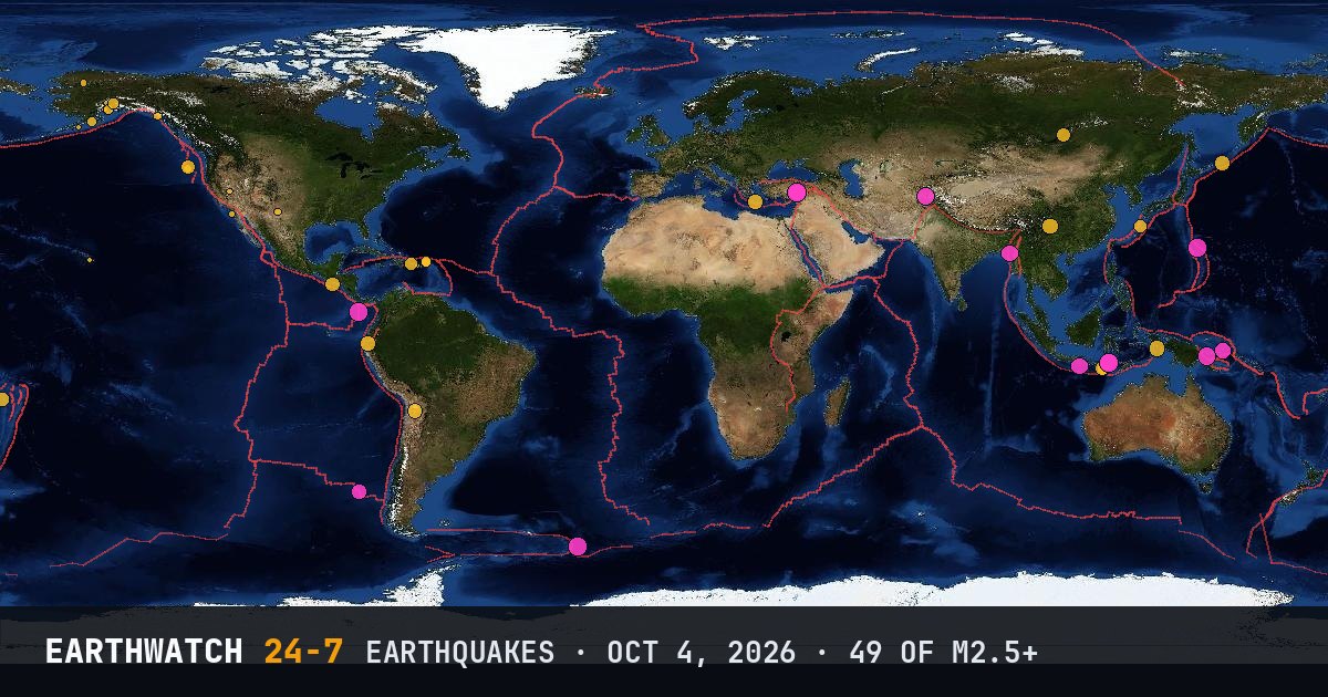
World map of the earthquakes on October 4, 2026

USGS recorded 49 earthquakes of magnitude 2.5 or larger around the world on Sunday, October 4, 2026 (UTC). 14 were magnitude 4.5 or stronger. The strongest was a magnitude 5.1 in the Volcano Islands, Japan region at 11:12 UTC. That is below the average of 61 a day over the previous 9 days.

Earthquakes M2.5+49
M4.5 and up14
M6 and up0
StrongestM5.1
Deepest558 km
Most activeAlaska
See it on the live 3D globe →Watch live on YouTube🔔 Get alerts near you

Strongest earthquakes

By magnitude

M2.5 – 3.918
M4.0 – 4.927
M5.0 – 5.94
M6.0 and up0

Most active regions

Every earthquake

Time (UTC)MagDepthWhere
00:484.310 km5 km SSW of Zonianá, Greece
01:384.994 km21 km NE of Lae, Papua New Guinea
01:474.910 kmSouth Sandwich Islands region
01:583.519 km32 km N of Fishhook, Alaska
03:083.310 km65 km NNE of Cruz Bay, U.S. Virgin Islands
03:103.217 km64 km NNE of Cruz Bay, U.S. Virgin Islands
03:142.58 km5 km WSW of Guánica, Puerto Rico
04:312.690 km9 km NE of Skwentna, Alaska
05:554.658 km121 km WNW of Chauk, Burma (Myanmar)
07:564.510 kmWest Chile Rise
08:113.410 km89 km NNE of Cruz Bay, U.S. Virgin Islands
08:203.022 km68 km N of Charlotte Amalie, U.S. Virgin Islands
08:574.343 km42 km WNW of Puerto Bolívar, Ecuador
08:594.0141 km3 km SW of Punta Cana, Dominican Republic
09:132.91 km41 km NNE of Ambler, Alaska
10:135.010 km37 km N of Ruteng, Indonesia
10:524.810 km43 km N of Ruteng, Indonesia
11:094.6162 km121 km SW of Kokopo, Papua New Guinea
11:125.110 kmVolcano Islands, Japan region
11:194.710 km21 km SSE of Saimbeyli, Turkey
11:364.710 km22 km E of Feke, Turkey
11:435.010 km21 km ESE of Feke, Turkey
12:074.2169 km77 km ESE of Ollagüe, Chile
12:182.716 km48 km SW of Primo Tapia, B.C., MX
12:364.653 km110 km S of Dampit, Indonesia
12:463.468 km14 km SSE of Funny River, Alaska
13:242.670 km18 km WNW of Clam Gulch, Alaska
13:383.465 km56 km W of Akhiok, Alaska
14:065.010 km295 km S of Burica, Panama
14:092.95 km31 km SSE of Hope, New Mexico
14:594.226 km65 km SW of Tambolaka, Indonesia
15:032.528 km60 km SSE of Perryville, Alaska
16:004.310 km20 km ESE of Feke, Turkey
16:303.05 km62 km WNW of Elfin Cove, Alaska
16:472.68 km35 km SE of Mina, Nevada
17:152.542 km27 km E of Honaunau-Napoopoo, Hawaii
17:194.410 km13 km N of Xunchang, China
17:284.212 km21 km E of Feke, Turkey
18:563.210 kmoff the coast of Oregon
20:164.435 km279 km ENE of Kuril’sk, Russia
20:274.8249 km32 km SSE of Jurm, Afghanistan
22:134.210 kmoff the coast of Oregon
22:164.1558 km147 km E of Levuka, Fiji
22:514.210 km21 km E of Feke, Turkey
22:544.210 km48 km W of Ust’-Barguzin, Russia
23:054.410 km152 km NE of Tual, Indonesia
23:194.135 km43 km S of Tambolaka, Indonesia
23:364.335 km82 km S of Acajutla, El Salvador
23:394.091 km33 km NNW of Uken, Japan

Data: USGS earthquake catalog, magnitude 2.5 and up, times in UTC. Outside the United States, USGS mainly lists quakes of about magnitude 4 and up, so smaller ones there are undercounted. Magnitudes and locations can be revised.

Did you know?

The contour lines. Lines around big quakes come from USGS ShakeMaps: the outer line is how far shaking was felt by most people, the inner line where it was strong.

← Oct 3All daysOct 5 →