EARTHQUAKES · DAILY

Earthquakes on Monday, October 5, 2026

Complete day, UTC
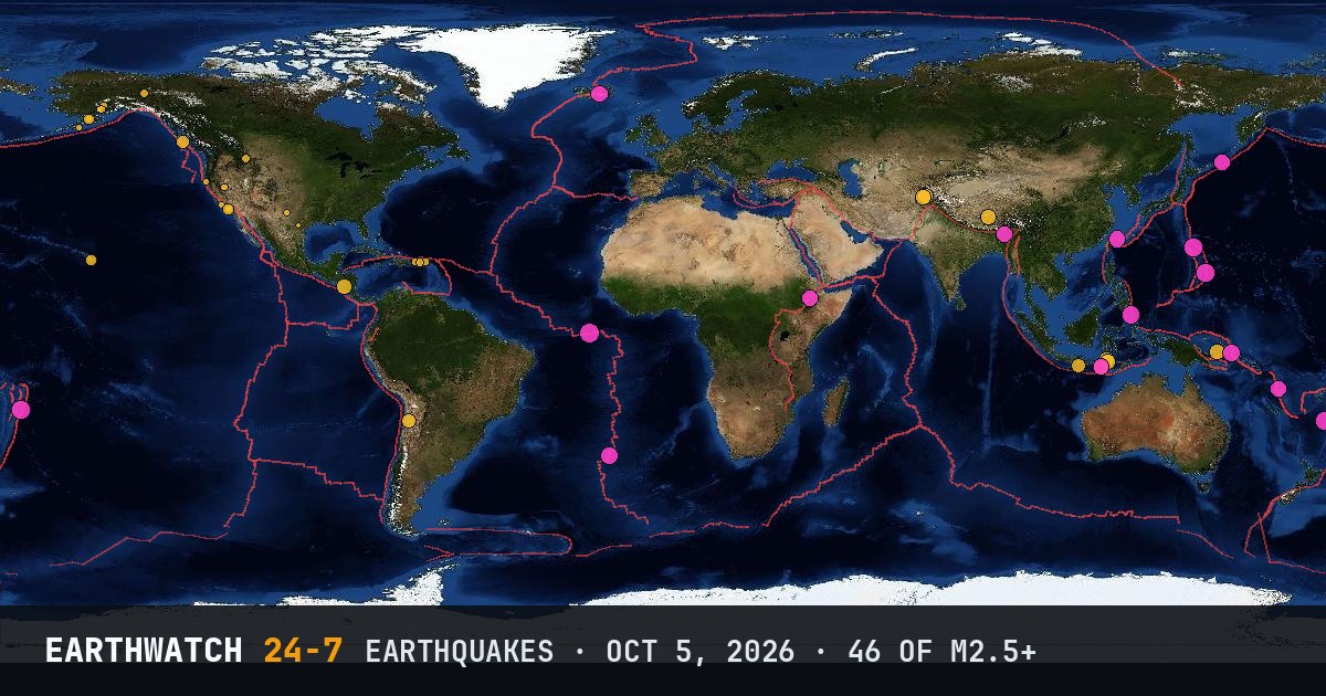
World map of the earthquakes on October 5, 2026

USGS recorded 46 earthquakes of magnitude 2.5 or larger around the world on Monday, October 5, 2026 (UTC). 15 were magnitude 4.5 or stronger. The strongest was a magnitude 5.3 in the central Mid-Atlantic Ridge at 01:18 UTC. That is below the average of 60 a day over the previous 10 days.

Earthquakes M2.5+46
M4.5 and up15
M6 and up0
StrongestM5.3
Deepest519 km
Most activeAlaska
See it on the live 3D globe →Watch live on YouTube🔔 Get alerts near you

Strongest earthquakes

By magnitude

M2.5 – 3.921
M4.0 – 4.921
M5.0 – 5.94
M6.0 and up0

Most active regions

Every earthquake

Time (UTC)MagDepthWhere
01:185.310 kmcentral Mid-Atlantic Ridge
01:204.4167 km12 km N of Villa El Carmen, Nicaragua
01:552.86 km22 km NNE of Yerington, Nevada
02:164.251 km111 km S of Dampit, Indonesia
02:343.15 km5 km NW of Ovando, Montana
02:444.310 km100 km N of Ruteng, Indonesia
03:052.924 km65 km NE of Cruz Bay, U.S. Virgin Islands
03:073.043 km34 km NNE of San Juan, Puerto Rico
04:164.535 kmKuril Islands
05:265.010 km71 km E of ‘Ohonua, Tonga
06:144.851 km191 km ESE of Sarangani, Philippines
07:134.935 kmVolcano Islands, Japan region
08:002.913 km42 km NW of San Antonio, Puerto Rico
08:254.294 km172 km ESE of Antofagasta, Chile
10:034.710 kmsouthern Mid-Atlantic Ridge
10:382.714 km70 km SE of Perryville, Alaska
10:525.010 km187 km ENE of Saipan, Northern Mariana Islands
11:063.0105 km50 km WNW of Ninilchik, Alaska
11:474.635 km21 km S of Luganville, Vanuatu
12:102.6125 km70 km WNW of Happy Valley, Alaska
12:174.440 km54 km WSW of Tambolaka, Indonesia
12:272.711 km21 km NNW of Midland, Texas
12:313.628 km12 km SW of Volcano, Hawaii
13:054.410 km53 km NNE of Ruteng, Indonesia
13:304.7156 km75 km NNE of Yonakuni, Japan
14:374.410 km218 km NNW of Rikaze, China
15:074.3191 km47 km SSW of Jurm, Afghanistan
15:402.79 km7 km SE of Goleta, California
15:562.821 km5 km NE of Hydesville, California
16:102.993 km45 km WNW of Beluga, Alaska
16:553.45 km83 km W of Karluk, Alaska
17:242.67 km12 km ESE of Pearsall, Texas
17:284.710 km105 km WNW of Höfn, Iceland
17:303.910 km247 km WNW of Port McNeill, Canada
18:052.71 km81 km W of Karluk, Alaska
18:284.4125 km21 km E of Kimbe, Papua New Guinea
19:474.610 km12 km ENE of Metahāra, Ethiopia
20:223.511 km31 km SW of Dana Point, California
20:225.0519 kmsouth of the Fiji Islands
20:232.817 km32 km SW of Dana Point, California
20:503.23 km17 km ESE of Eagle Village, Alaska
21:384.535 km39 km SW of Tambolaka, Indonesia
21:384.3203 km17 km WNW of Ashkāsham, Afghanistan
22:062.511 km31 km SW of Dana Point, California
22:484.8142 km146 km WNW of Panguna, Papua New Guinea
22:534.610 km31 km S of Tezpur, India

Data: USGS earthquake catalog, magnitude 2.5 and up, times in UTC. Outside the United States, USGS mainly lists quakes of about magnitude 4 and up, so smaller ones there are undercounted. Magnitudes and locations can be revised.

Did you know?

Why depth matters. Shallow quakes (under 70 km) usually shake the surface much harder than deep quakes of the same magnitude.

← Oct 4All daysOct 6 →