EARTHQUAKES · DAILY

Earthquakes on Wednesday, October 7, 2026

Complete day, UTC
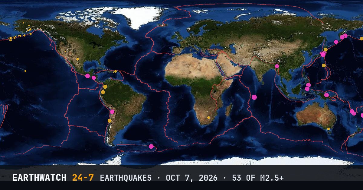
World map of the earthquakes on October 7, 2026

USGS recorded 53 earthquakes of magnitude 2.5 or larger around the world on Wednesday, October 7, 2026 (UTC). 19 were magnitude 4.5 or stronger. The strongest was a magnitude 5.2 in the Chagos Archipelago region at 14:59 UTC. That is close to the average of 59 a day over the previous 12 days.

Earthquakes M2.5+53
M4.5 and up19
M6 and up0
StrongestM5.2
Deepest529 km
Most activeAlaska
See it on the live 3D globe →Watch live on YouTube🔔 Get alerts near you

Strongest earthquakes

By magnitude

M2.5 – 3.927
M4.0 – 4.925
M5.0 – 5.91
M6.0 and up0

Most active regions

Every earthquake

Time (UTC)MagDepthWhere
00:224.553 km37 km ESE of Iwaki, Japan
00:242.788 km3 km SSW of La Playa, Puerto Rico
00:304.862 km57 km E of Petropavlovsk-Kamchatsky, Russia
00:442.523 km96 km SSW of Unalaska, Alaska
00:452.65 km103 km SSE of King Cove, Alaska
01:033.25 km225 km SE of Chiniak, Alaska
01:044.510 kmsoutheast of the Loyalty Islands
01:294.410 km21 km SW of Roncesvalles, Colombia
01:314.230 km101 km ENE of Noda, Japan
01:332.97 km184 km SSE of Unalaska, Alaska
01:394.6109 kmKuril Islands
02:032.815 km95 km SSW of Nikolski, Alaska
02:133.215 km94 km SSW of Nikolski, Alaska
02:212.514 km34 km SE of Sand Point, Alaska
02:252.544 km8 km E of Sterling, Alaska
02:263.020 km101 km SSE of Sand Point, Alaska
02:494.810 km132 km ENE of Tadine, New Caledonia
03:294.5110 km65 km NNE of Mawlaik, Burma (Myanmar)
03:453.214 km154 km SW of Nikolski, Alaska
04:042.530 km83 km ESE of Akutan, Alaska
04:394.910 kmSouth Sandwich Islands region
04:393.08 km11 km SSE of Leilani Estates, Hawaii
05:092.610 km93 km SSE of Sand Point, Alaska
06:033.110 km245 km SE of Chignik, Alaska
07:434.962 km80 km SW of El Arenal, Mexico
08:474.0108 kmRat Islands, Aleutian Islands, Alaska
09:094.373 km18 km SE of Coquimbo, Chile
10:204.5529 kmsouth of the Fiji Islands
10:574.7140 km22 km WNW of Manado, Indonesia
11:173.510 km13 km ENE of Nyora, Australia
11:312.75 km18 km W of Preston, Nevada
11:502.721 km33 km N of Kobuk, Alaska
12:263.210 kmsouth of the Aleutian Islands
12:353.65 km17 km E of Orkney, South Africa
14:083.440 km81 km NNE of Luquillo, Puerto Rico
14:595.210 kmChagos Archipelago region
15:464.7106 km45 km WNW of Ollagüe, Chile
16:064.3162 km23 km E of Palora, Ecuador
16:424.7117 km34 km E of Sarangani, Philippines
17:022.576 km85 km ESE of Akutan, Alaska
17:173.62 km10 km SW of Coyanosa, Texas
17:364.6102 km48 km SSW of Angoram, Papua New Guinea
17:453.323 km22 km SW of Hope, Alaska
17:542.610 km148 km SSE of Alcan Border, Alaska
17:594.3249 kmVolcano Islands, Japan region
18:134.6504 kmsouth of the Fiji Islands
18:154.810 km194 km S of Ust’-Kamchatsk Staryy, Russia
18:592.874 km16 km WSW of Anchor Point, Alaska
19:134.973 km3 km WSW of Shibayama, Japan
19:364.696 km9 km NNE of Midori, Japan
20:564.6206 km18 km NNE of Posoltega, Nicaragua
22:144.380 km15 km ENE of Ōarai, Japan
23:352.614 km51 km SW of Manley Hot Springs, Alaska

Data: USGS earthquake catalog, magnitude 2.5 and up, times in UTC. Outside the United States, USGS mainly lists quakes of about magnitude 4 and up, so smaller ones there are undercounted. Magnitudes and locations can be revised.

Did you know?

North America's biggest. The 1964 Great Alaska earthquake measured M9.2, the largest ever recorded in North America. Alaska has more large quakes than any other US state.

← Oct 6All daysOct 8 →