EARTHQUAKES · DAILY

Earthquakes on Tuesday, October 13, 2026

Complete day, UTC
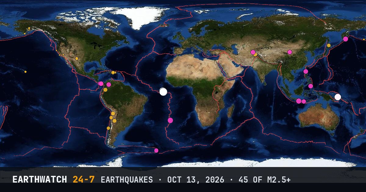
World map of the earthquakes on October 13, 2026

USGS recorded 45 earthquakes of magnitude 2.5 or larger around the world on Tuesday, October 13, 2026 (UTC). 19 were magnitude 4.5 or stronger, including 3 of magnitude 6 or more. The strongest was a magnitude 6.8 in the central Mid-Atlantic Ridge at 12:23 UTC. That is below the average of 58 a day over the previous 18 days.

Earthquakes M2.5+45
M4.5 and up19
M6 and up3
StrongestM6.8
Deepest277 km
Most activePanama
See it on the live 3D globe →Watch live on YouTube🔔 Get alerts near you

Strongest earthquakes

By magnitude

M2.5 – 3.917
M4.0 – 4.921
M5.0 – 5.94
M6.0 and up3

Most active regions

Every earthquake

Time (UTC)MagDepthWhere
00:024.610 km23 km WNW of Río Grande, Panama
00:354.1277 km81 km NE of Esashi, Japan
01:093.16 km12 km SSE of Fern Forest, Hawaii
01:444.026 km62 km NW of Tomé, Chile
02:164.5140 kmSouth Sandwich Islands region
02:182.87 kmRat Islands, Aleutian Islands, Alaska
02:484.710 km9 km SSE of La Mesa, Panama
03:044.4128 km38 km NE of Chilecito, Argentina
04:005.110 km119 km SSW of Gambiran Satu, Indonesia
04:154.310 km11 km SSW of Tebario, Panama
05:102.586 km48 km NW of Ninilchik, Alaska
05:284.410 km13 km ESE of Pedasí, Panama
05:446.710 kmcentral Mid-Atlantic Ridge
06:014.710 km124 km N of Pagudpud, Philippines
06:052.914 km10 km N of Animas, Puerto Rico
06:394.710 km14 km WNW of Río Grande, Panama
06:512.81 km91 km W of Akhiok, Alaska
08:154.610 km63 km W of Bayan Hot, China
08:283.099 km34 km N of Skwentna, Alaska
08:385.310 kmsouthern Mid-Atlantic Ridge
09:414.710 km9 km NE of Boshkengash, Tajikistan
09:484.535 km71 km SW of Tambolaka, Indonesia
10:152.79 km19 km WSW of Petrolia, California
10:412.717 km6 km NE of Isabela, Puerto Rico
11:413.422 km54 km NNE of Otra Banda, Dominican Republic
12:054.910 km180 km SE of Vilyuchinsk, Russia
12:124.3189 km36 km S of Jurm, Afghanistan
12:236.810 kmcentral Mid-Atlantic Ridge
12:384.132 km38 km SSW of Taltal, Chile
12:514.510 km26 km SSW of Zapotillo, Panama
13:552.72 km15 km NE of Little Lake, California
14:242.556 km15 km NNE of Ridgeway, Alaska
14:365.318 km122 km S of Kokopo, Papua New Guinea
15:214.866 km8 km SE of Sarangani, Philippines
15:553.9117 km9 km ENE of La Romana, Dominican Republic
16:285.128 km119 km S of Kokopo, Papua New Guinea
18:282.60 km28 km SSE of Lopez Point, California
18:364.410 km20 km WSW of Palestina, Colombia
18:456.021 km126 km S of Kokopo, Papua New Guinea
19:272.734 km19 km SSW of Leilani Estates, Hawaii
21:244.8162 km5 km NW of Cepitá, Colombia
22:393.610 km23 km WSW of Carlsbad, New Mexico
23:264.4124 km70 km NNE of Calama, Chile
23:292.822 km7 km NNE of Isabela, Puerto Rico
23:542.69 km51 km S of Whites City, New Mexico

Data: USGS earthquake catalog, magnitude 2.5 and up, times in UTC. Outside the United States, USGS mainly lists quakes of about magnitude 4 and up, so smaller ones there are undercounted. Magnitudes and locations can be revised.

Did you know?

Earthquakes every day. Thousands of earthquakes happen around the world every day, but most are too small for anyone to feel.

← Oct 12All daysOct 14 →