EARTHQUAKES · DAILY

Earthquakes on Monday, October 12, 2026

Complete day, UTC
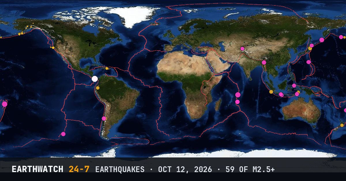
World map of the earthquakes on October 12, 2026

USGS recorded 59 earthquakes of magnitude 2.5 or larger around the world on Monday, October 12, 2026 (UTC). 27 were magnitude 4.5 or stronger, including 1 of magnitude 6 or more. The strongest was a magnitude 6.1 near Río Grande, Panama at 23:20 UTC. That is close to the average of 58 a day over the previous 17 days.

Earthquakes M2.5+59
M4.5 and up27
M6 and up1
StrongestM6.1
Deepest471 km
Most activeAlaska
See it on the live 3D globe →Watch live on YouTube🔔 Get alerts near you

Strongest earthquakes

By magnitude

M2.5 – 3.924
M4.0 – 4.932
M5.0 – 5.92
M6.0 and up1

Most active regions

Every earthquake

Time (UTC)MagDepthWhere
00:534.6200 kmVolcano Islands, Japan region
01:284.878 km56 km E of Yairipok, India
01:302.926 km197 km WSW of Adak, Alaska
01:594.810 kmsouthern East Pacific Rise
02:224.510 km7 km ENE of Lajamina, Panama
02:402.894 km37 km W of Petersville, Alaska
02:532.87 km19 km N of Glacier View, Alaska
02:593.6117 km8 km ENE of La Romana, Dominican Republic
03:044.527 km42 km S of Daroot-Korgon, Kyrgyzstan
03:444.566 km53 km S of Kushiro, Japan
04:154.210 km8 km SSE of Llano de Piedra, Panama
04:182.663 km3 km W of Mayagüez, Puerto Rico
04:385.5195 km122 km W of Neiafu, Tonga
05:154.5471 kmsouth of the Fiji Islands
05:284.6121 km25 km SSE of Blitar, Indonesia
06:524.232 km25 km SSE of Pahiatua, New Zealand
07:084.1164 km27 km WSW of Palora, Ecuador
07:164.510 km7 km ESE of Tebario, Panama
07:252.525 km63 km SSE of Perryville, Alaska
08:242.56 km56 km S of Whites City, New Mexico
08:304.722 km219 km E of Lospalos, Timor Leste
08:594.649 km122 km SE of Bitung, Indonesia
09:122.77 km26 km W of Petrolia, California
10:294.3107 km31 km ESE of Puente Alto, Chile
11:074.310 km6 km NNW of El Cortezo, Panama
11:285.410 kmMid-Indian Ridge
11:453.40 km32 km W of Petrolia, California
11:584.655 km100 km SSW of Kencong, Indonesia
12:132.55 km26 km WSW of Petrolia, California
12:132.64 km13 km NNW of Gerlach, Nevada
12:242.65 km36 km WNW of Central, Alaska
13:053.535 km105 km SSE of Sand Point, Alaska
13:174.510 km6 km W of Tonosí, Panama
13:444.810 kmMid-Indian Ridge
14:192.6133 km73 km WNW of Ninilchik, Alaska
14:294.610 km194 km SE of Attu Station, Alaska
15:213.41 km29 km W of Petrolia, California
15:312.518 km57 km S of Ivanof Bay, Alaska
15:363.420 km15 km NNE of Miches, Dominican Republic
15:444.935 km283 km SSW of Severo-Kuril’sk, Russia
17:162.5102 km57 km SE of Ugashik, Alaska
17:172.812 km198 km S of Sand Point, Alaska
17:254.435 km54 km E of Miyako, Japan
17:422.527 km173 km S of Akhiok, Alaska
18:174.834 km23 km SW of San Antonio, Chile
18:274.710 kmMid-Indian Ridge
18:304.610 kmMid-Indian Ridge
18:342.810 km237 km W of Ferndale, California
20:054.810 km25 km W of Río Grande, Panama
21:434.510 km21 km WNW of Río Grande, Panama
21:484.510 km5 km WSW of Calidonia, Panama
22:263.427 kmRat Islands, Aleutian Islands, Alaska
23:206.111 km17 km W of Río Grande, Panama
23:233.56 km148 km SE of Chignik, Alaska
23:352.584 km30 km WSW of Petersville, Alaska
23:364.910 km17 km W of Río Grande, Panama
23:434.1130 km274 km WSW of Tual, Indonesia
23:454.510 km24 km SW of Zapotillo, Panama
23:474.410 km213 km S of Bengkulu, Indonesia

Data: USGS earthquake catalog, magnitude 2.5 and up, times in UTC. Outside the United States, USGS mainly lists quakes of about magnitude 4 and up, so smaller ones there are undercounted. Magnitudes and locations can be revised.

Did you know?

The Ring of Fire. Most of the world's largest earthquakes happen around the edges of the Pacific Ocean, where ocean plates dive beneath continents.

← Oct 11All daysOct 13 →