EARTHQUAKES · DAILY

Earthquakes on Sunday, October 11, 2026

Complete day, UTC
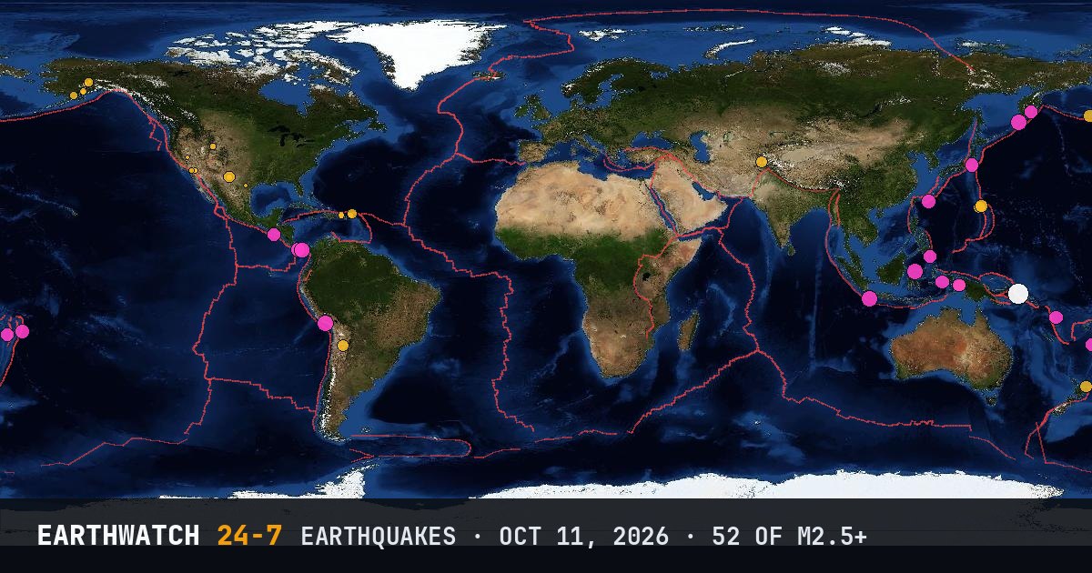
World map of the earthquakes on October 11, 2026

USGS recorded 52 earthquakes of magnitude 2.5 or larger around the world on Sunday, October 11, 2026 (UTC). 21 were magnitude 4.5 or stronger, including 1 of magnitude 6 or more. The strongest was a magnitude 6.2 near Panguna, Papua New Guinea at 14:07 UTC. That is close to the average of 58 a day over the previous 16 days.

Earthquakes M2.5+52
M4.5 and up21
M6 and up1
StrongestM6.2
Deepest546 km
Most activeAlaska
See it on the live 3D globe →Watch live on YouTube🔔 Get alerts near you

Strongest earthquakes

By magnitude

M2.5 – 3.920
M4.0 – 4.926
M5.0 – 5.95
M6.0 and up1

Most active regions

Every earthquake

Time (UTC)MagDepthWhere
00:064.610 km18 km WNW of Río Grande, Panama
00:404.367 km24 km WNW of Hicks Bay, New Zealand
01:505.010 km3 km NW of Flores, Panama
02:354.6121 km109 km SSE of Pondaguitan, Philippines
03:184.410 km3 km NW of Pitaloza Arriba, Panama
03:305.210 km180 km S of Pelabuhanratu, Indonesia
05:074.711 km110 km SSE of Sola, Vanuatu
05:134.2325 kmMariana Islands region
06:223.080 km40 km W of Anchor Point, Alaska
07:074.2199 km26 km SE of Jurm, Afghanistan
07:112.510 km26 km SW of Mina, Nevada
07:284.5546 kmsouth of the Fiji Islands
07:353.730 km164 km NE of Cruz Bay, U.S. Virgin Islands
08:042.712 km4 km E of San Jacinto, California
08:044.06 km56 km S of Whites City, New Mexico
08:062.99 km61 km S of Whites City, New Mexico
08:082.926 km37 km NW of San Antonio, Puerto Rico
08:122.56 km56 km S of Whites City, New Mexico
08:273.4153 km61 km ESE of King Salmon, Alaska
10:054.6513 km260 km WNW of Houma, Tonga
10:432.7109 km37 km WNW of Skwentna, Alaska
10:572.66 km14 km ESE of Pearsall, Texas
11:184.669 km82 km E of Petropavlovsk-Kamchatsky, Russia
12:134.810 km165 km SSE of Miyakojima, Japan
12:164.495 km275 km W of Adak, Alaska
12:412.699 km64 km SE of Pedro Bay, Alaska
13:153.6104 km39 km N of Petersville, Alaska
13:312.5111 km59 km N of Petersville, Alaska
13:425.245 km18 km SSE of Camaná, Peru
14:076.254 km79 km SSE of Panguna, Papua New Guinea
14:574.310 km125 km SE of Nabire, Indonesia
16:244.756 km6 km ESE of Tōgane, Japan
17:005.283 km101 km SSW of Severo-Kuril’sk, Russia
17:054.410 kmVolcano Islands, Japan region
17:093.014 km66 km NNE of Cruz Bay, U.S. Virgin Islands
17:114.810 km31 km W of Río Grande, Panama
18:064.710 km156 km ESE of Neiafu, Tonga
18:123.022 km70 km NW of San Antonio, Puerto Rico
18:142.788 km44 km WSW of Anchor Point, Alaska
18:294.410 km9 km SW of Tebario, Panama
18:474.610 km184 km W of Fakfak, Indonesia
20:252.777 km28 km NNE of Skwentna, Alaska
20:522.70 km33 km WNW of Desert Center, California
21:194.510 km27 km W of Río Grande, Panama
21:282.70 km33 km WNW of Desert Center, California
21:334.3196 km61 km WNW of San Antonio de los Cobres, Argentina
21:345.2111 km152 km W of Gorontalo, Indonesia
22:074.510 km116 km SE of Nabire, Indonesia
22:254.410 km18 km WSW of Río Grande, Panama
22:404.610 km0 km NE of Leones Arriba, Panama
23:204.535 km103 km SSW of La Libertad, El Salvador
23:342.80 km10 km N of Little America, Wyoming

Data: USGS earthquake catalog, magnitude 2.5 and up, times in UTC. Outside the United States, USGS mainly lists quakes of about magnitude 4 and up, so smaller ones there are undercounted. Magnitudes and locations can be revised.

Did you know?

Aftershocks. Big earthquakes are followed by aftershocks that can go on for weeks or even years, usually getting smaller and less frequent over time.

← Oct 10All daysOct 12 →