EARTHQUAKES · DAILY

Earthquakes on Saturday, October 10, 2026

Complete day, UTC
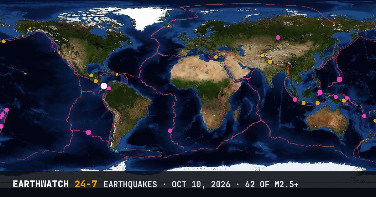
World map of the earthquakes on October 10, 2026

USGS recorded 62 earthquakes of magnitude 2.5 or larger around the world on Saturday, October 10, 2026 (UTC). 37 were magnitude 4.5 or stronger, including 1 of magnitude 6 or more. The strongest was a magnitude 6.0 near La Tronosa, Panama at 04:14 UTC. That is close to the average of 58 a day over the previous 15 days.

Earthquakes M2.5+62
M4.5 and up37
M6 and up1
StrongestM6.0
Deepest587 km
Most activePanama
See it on the live 3D globe →Watch live on YouTube🔔 Get alerts near you

Strongest earthquakes

By magnitude

M2.5 – 3.98
M4.0 – 4.948
M5.0 – 5.95
M6.0 and up1

Most active regions

Every earthquake

Time (UTC)MagDepthWhere
00:034.810 km5 km SW of Cañas, Panama
00:384.710 km85 km ENE of Tadine, New Caledonia
00:454.010 km2 km SE of Pedasí, Panama
00:474.710 km7 km S of Trudarmeyskiy, Russia
00:514.610 km9 km NNE of La Tronosa, Panama
01:114.710 km10 km N of La Tronosa, Panama
01:354.610 km10 km S of Río Grande, Panama
02:005.110 km133 km WNW of Ternate, Indonesia
02:265.110 km1 km NNE of Tonosí, Panama
02:434.510 km18 km SSE of Río Grande, Panama
02:483.48 km14 km N of Brooktrails, California
03:012.818 km2 km S of Las Marías, Puerto Rico
03:564.710 km8 km N of La Tronosa, Panama
03:585.3112 km41 km NNE of Yigo Village, Guam
04:146.010 km7 km N of La Tronosa, Panama
04:334.510 km9 km WNW of Flores, Panama
04:454.468 km53 km NW of Pante Makasar, Timor Leste
04:512.60 km13 km S of Honaunau-Napoopoo, Hawaii
05:114.410 km121 km SW of Jiquilillo, Nicaragua
05:214.410 km21 km SSW of Río Grande, Panama
05:325.010 km141 km E of Bitung, Indonesia
05:454.5115 km6 km WSW of Filadelfia, Colombia
06:044.310 km5 km N of Tebario, Panama
06:164.510 km25 km SSE of Pedasí, Panama
06:172.579 km60 km SSW of False Pass, Alaska
06:184.910 km10 km SSW of Cañas, Panama
06:274.710 km26 km S of Pedasí, Panama
06:304.910 km26 km SSE of Pedasí, Panama
06:474.510 km10 km SE of Pedasí, Panama
07:134.610 km6 km SSE of Llano de Piedra, Panama
07:244.410 km2 km WSW of Llano de Piedra, Panama
07:474.210 km4 km W of Aquiles Serdán 1ra. Sección, Mexico
08:384.579 km61 km N of Hihifo, Tonga
08:523.019 km63 km NW of San Antonio, Puerto Rico
09:344.1512 kmsouth of the Fiji Islands
09:424.630 km31 km SE of Vanimo, Papua New Guinea
09:484.210 km16 km SSE of Los Asientos, Panama
10:114.457 km32 km WSW of Kandrian, Papua New Guinea
10:354.810 km4 km NE of Río Grande, Panama
11:534.369 km88 km S of Wonosari, Indonesia
12:214.6560 km268 km WNW of Houma, Tonga
12:304.210 km167 km S of Adak, Alaska
12:344.310 km3 km SSW of Tebario, Panama
13:224.510 km4 km NW of Los Asientos, Panama
13:404.6587 kmsouth of the Fiji Islands
13:464.810 km12 km NE of La Tronosa, Panama
14:184.494 kmsouth of the Kermadec Islands
14:374.422 km15 km ENE of Uttarkāshi, India
14:514.510 km10 km NNW of El Cortezo, Panama
14:594.510 km5 km WNW of Guarumal, Panama
15:104.610 km51 km NNW of Rabaul, Papua New Guinea
15:584.810 km11 km SSW of Tebario, Panama
16:054.714 km2 km WNW of El Cacao, Panama
16:323.484 km31 km NE of Punta Cana, Dominican Republic
19:154.610 kmsouthern Mid-Atlantic Ridge
19:423.020 km68 km SE of Perryville, Alaska
20:354.9118 kmKermadec Islands region
21:345.310 kmsoutheast of Easter Island
21:384.530 km171 km SSW of Pagar Alam, Indonesia
22:334.210 km31 km WNW of Fry, Greece
23:114.1204 km29 km ESE of Jurm, Afghanistan
23:423.1113 km43 km NNW of Petersville, Alaska

Data: USGS earthquake catalog, magnitude 2.5 and up, times in UTC. Outside the United States, USGS mainly lists quakes of about magnitude 4 and up, so smaller ones there are undercounted. Magnitudes and locations can be revised.

Did you know?

Reading the waves. Seismometers pick up fast P waves first, then slower S waves. The gap between them tells scientists how far away a quake was.

← Oct 9All daysOct 11 →