EARTHQUAKES · DAILY

Earthquakes on Thursday, October 15, 2026

Complete day, UTC
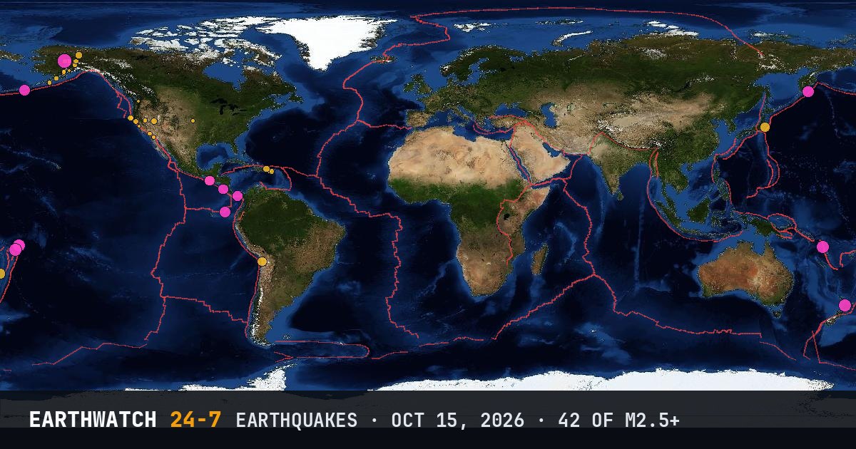
World map of the earthquakes on October 15, 2026

USGS recorded 42 earthquakes of magnitude 2.5 or larger around the world on Thursday, October 15, 2026 (UTC). 12 were magnitude 4.5 or stronger. The strongest was a magnitude 5.6 near Lake Minchumina, Alaska at 11:07 UTC. That is below the average of 56 a day over the previous 20 days.

Earthquakes M2.5+42
M4.5 and up12
M6 and up0
StrongestM5.6
Deepest523 km
Most activeAlaska
See it on the live 3D globe →Watch live on YouTube🔔 Get alerts near you

Strongest earthquakes

By magnitude

M2.5 – 3.926
M4.0 – 4.911
M5.0 – 5.95
M6.0 and up0

Most active regions

Every earthquake

Time (UTC)MagDepthWhere
01:092.619 km5 km SW of Wilderness Rim, Washington
02:054.436 km100 km ESE of Takahagi, Japan
03:302.814 km3 km NNW of San Jacinto, California
03:364.814 km30 km E of Safotu, Samoa
03:365.113 km36 km E of Safotu, Samoa
03:572.5126 km59 km NNW of Petersville, Alaska
04:333.06 km26 km SE of Emajagua, Puerto Rico
05:255.3286 km43 km SSE of Otorohanga, New Zealand
06:063.02 km7 km NW of The Geysers, California
06:302.820 km72 km S of Perryville, Alaska
06:422.91 km63 km ENE of Lake Minchumina, Alaska
06:532.716 km1 km SSE of Maria Antonia, Puerto Rico
08:442.8110 km57 km E of Pedro Bay, Alaska
09:342.89 km20 km ESE of Silver Springs, Nevada
10:373.211 km74 km W of Petrolia, California
11:075.64 km43 km NNW of Lake Minchumina, Alaska
11:164.810 kmoff the coast of Ecuador
12:182.659 km88 km N of Aleneva, Alaska
13:053.08 km40 km NNW of Lake Minchumina, Alaska
13:065.210 km157 km W of Sola, Vanuatu
13:164.710 km114 km SSW of Nikolski, Alaska
13:295.210 km107 km NNE of Hihifo, Tonga
13:314.510 km9 km SSE of Los Asientos, Panama
14:023.0108 km56 km ENE of Ferry, Alaska
14:092.715 km20 km W of Delta, B.C., MX
14:594.910 km198 km SSE of Vilyuchinsk, Russia
15:404.523 km22 km W of Tamarindo, Costa Rica
16:324.4523 kmsouth of the Fiji Islands
17:182.79 km7 km SSW of Luray, Kansas
17:202.814 km59 km ENE of Lake Minchumina, Alaska
17:253.020 km13 km W of Petrolia, California
17:562.554 km15 km ESE of Kasilof, Alaska
17:572.55 km10 km ESE of Gilroy, California
19:352.7112 km62 km W of Happy Valley, Alaska
19:463.65 km41 km NNE of Beaver, Alaska
19:582.90 km86 km SE of Ugashik, Alaska
20:254.372 km11 km SE of Huara, Chile
20:394.560 km44 km SSE of Champerico, Guatemala
21:123.410 km65 km NE of Punta Cana, Dominican Republic
21:294.436 km52 km S of Champerico, Guatemala
22:553.45 km19 km W of Preston, Nevada
23:302.952 km72 km SSE of Cantwell, Alaska

Data: USGS earthquake catalog, magnitude 2.5 and up, times in UTC. Outside the United States, USGS mainly lists quakes of about magnitude 4 and up, so smaller ones there are undercounted. Magnitudes and locations can be revised.

← Oct 14All daysOct 16 →