EARTHQUAKES · DAILY

Earthquakes on Friday, October 16, 2026

Complete day, UTC
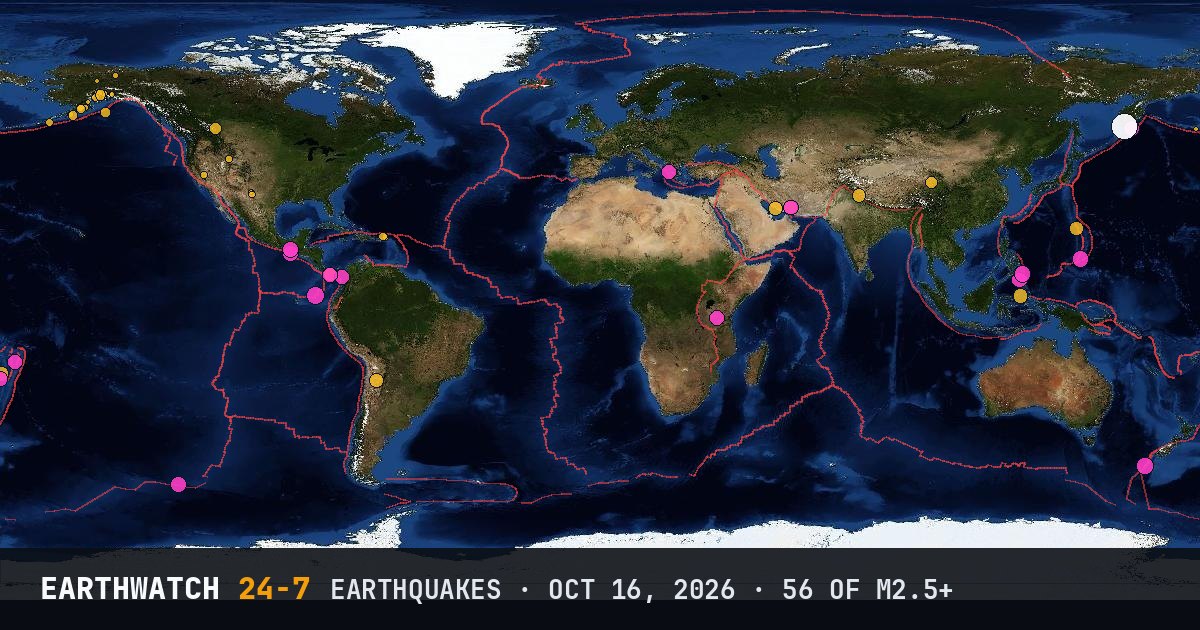
World map of the earthquakes on October 16, 2026

USGS recorded 56 earthquakes of magnitude 2.5 or larger around the world on Friday, October 16, 2026 (UTC). 17 were magnitude 4.5 or stronger, including 1 of magnitude 6 or more. The strongest was a magnitude 6.9 near Ozernovskiy, Russia at 03:35 UTC. That is close to the average of 56 a day over the previous 21 days.

Earthquakes M2.5+56
M4.5 and up17
M6 and up1
StrongestM6.9
Deepest594 km
Most activeAlaska
See it on the live 3D globe →Watch live on YouTube🔔 Get alerts near you

Strongest earthquakes

By magnitude

M2.5 – 3.928
M4.0 – 4.925
M5.0 – 5.92
M6.0 and up1

Most active regions

Every earthquake

Time (UTC)MagDepthWhere
00:043.168 km5 km N of Nikiski, Alaska
00:182.760 km32 km N of Karluk, Alaska
00:374.010 km191 km NW of Oula Xiuma, China
00:373.119 km95 km SSE of Akutan, Alaska
01:504.410 km12 km SSE of Tebario, Panama
02:052.515 km42 km NW of Rampart, Alaska
02:082.556 kmRat Islands, Aleutian Islands, Alaska
02:123.47 km86 km SE of Perryville, Alaska
02:422.654 km29 km SE of Perryville, Alaska
03:356.9135 km76 km NE of Ozernovskiy, Russia
03:574.3343 kmMariana Islands region
04:424.710 km95 km SW of Brisas Barra de Suchiate, Mexico
05:224.410 km8 km SSE of Guarumal, Panama
05:263.368 km76 km WSW of Karluk, Alaska
06:353.24 km80 km W of Karluk, Alaska
06:372.90 km7 km W of Bennington, Idaho
06:443.05 km79 km W of Karluk, Alaska
07:412.514 km19 km ENE of Girdwood, Alaska
08:554.410 km66 km N of Mīnāb, Iran
09:014.4594 kmsouth of the Fiji Islands
09:044.810 kmsouthern East Pacific Rise
09:134.974 km31 km ENE of Kinablangan, Philippines
10:464.08 km31 km NNE of Banff, Canada
11:042.85 km24 km N of Sutton-Alpine, Alaska
11:112.67 km62 km NE of Venetie, Alaska
11:394.8109 km7 km WSW of Soconusco, Mexico
11:574.910 km119 km SSW of Merizo Village, Guam
12:012.819 km81 km NNE of Cruz Bay, U.S. Virgin Islands
12:184.710 km10 km SE of Lamitan, Philippines
12:372.6117 km54 km SSE of Pedro Bay, Alaska
13:024.526 km51 km ESE of Juradó, Colombia
13:282.80 km19 km SW of Toms Place, California
14:095.010 kmAuckland Islands, New Zealand region
14:353.256 km72 km NNW of Charlotte Amalie, U.S. Virgin Islands
14:493.650 km2 km NW of Knik, Alaska
15:064.6248 km153 km W of Neiafu, Tonga
15:084.710 km186 km SSE of Vilyuchinsk, Russia
15:272.50 km28 km SSE of Nelchina, Alaska
15:414.310 km31 km WSW of Mohr, Iran
16:174.610 km41 km NNE of Kilimatinde, Tanzania
16:264.472 km111 km ESE of Bitung, Indonesia
17:162.572 km18 km SSE of Skwentna, Alaska
17:243.047 km21 km SSW of Trapper Creek, Alaska
19:093.618 km282 km ESE of Chiniak, Alaska
19:345.210 kmoff the coast of Ecuador
19:512.611 km48 km SSE of Nelchina, Alaska
21:152.96 km58 km S of Whites City, New Mexico
21:264.5535 kmsouth of the Fiji Islands
21:304.510 km70 km NNE of Mīnāb, Iran
21:392.671 km24 km W of Susitna, Alaska
21:464.4160 km80 km W of San Antonio de los Cobres, Argentina
22:292.54 km33 km SSE of Hope, New Mexico
22:414.610 km12 km SSE of Tebario, Panama
23:064.326 km10 km SE of Rāmpur, India
23:352.56 km22 km W of Carlsbad, New Mexico
23:574.610 km6 km NNE of Sámi, Greece

Data: USGS earthquake catalog, magnitude 2.5 and up, times in UTC. Outside the United States, USGS mainly lists quakes of about magnitude 4 and up, so smaller ones there are undercounted. Magnitudes and locations can be revised.

← Oct 15All daysOct 17 →