EARTHQUAKES · DAILY

Earthquakes on Monday, October 19, 2026

Complete day, UTC
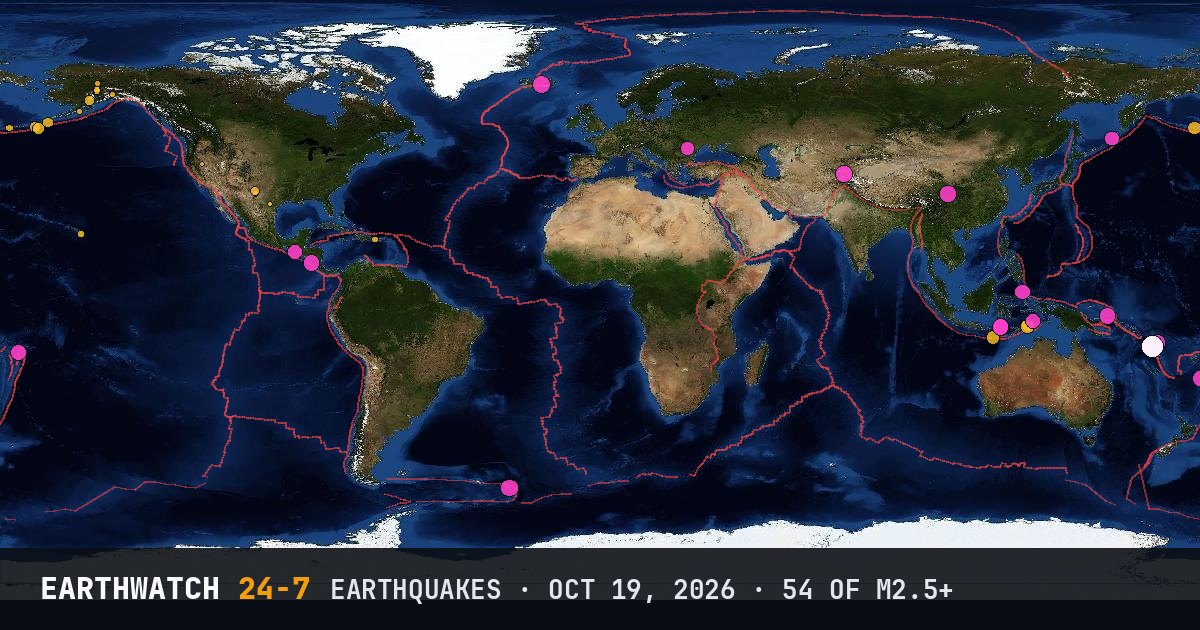
World map of the earthquakes on October 19, 2026

USGS recorded 54 earthquakes of magnitude 2.5 or larger around the world on Monday, October 19, 2026 (UTC). 28 were magnitude 4.5 or stronger, including 1 of magnitude 6 or more. The strongest was a magnitude 6.0 near Port-Olry, Vanuatu at 07:49 UTC. That is close to the average of 54 a day over the previous 24 days.

Earthquakes M2.5+54
M4.5 and up28
M6 and up1
StrongestM6.0
Deepest536 km
Most activeVanuatu
See it on the live 3D globe →Watch live on YouTube🔔 Get alerts near you

Strongest earthquakes

By magnitude

M2.5 – 3.921
M4.0 – 4.923
M5.0 – 5.99
M6.0 and up1

Most active regions

Every earthquake

Time (UTC)MagDepthWhere
00:522.76 km18 km SW of Jal, New Mexico
00:542.66 km18 km SW of Jal, New Mexico
00:593.018 km53 km SW of Adak, Alaska
01:372.77 km17 km SW of Jal, New Mexico
01:492.913 km13 km SSW of Waikoloa, Hawaii
03:422.66 km18 km SW of Jal, New Mexico
04:512.713 km120 km SE of Ugashik, Alaska
04:572.96 km25 km WNW of Puerto Real, Puerto Rico
05:084.010 km161 km S of Nikolski, Alaska
05:184.944 km68 km WSW of San Juan del Sur, Nicaragua
06:154.5158 kmBanda Sea
06:252.52 km5 km WSW of Burning Man Earth, Nevada
07:004.910 km218 km WNW of Port-Olry, Vanuatu
07:204.910 km203 km WNW of Port-Olry, Vanuatu
07:496.010 km186 km NW of Port-Olry, Vanuatu
07:555.310 km188 km NW of Port-Olry, Vanuatu
08:033.5126 km52 km E of Pedro Bay, Alaska
08:125.410 km184 km WNW of Port-Olry, Vanuatu
08:215.210 km211 km WNW of Port-Olry, Vanuatu
08:514.5125 km2 km W of Lunca Jariștei, Romania
08:544.910 km202 km NW of Port-Olry, Vanuatu
09:004.749 km163 km WNW of Tobelo, Indonesia
09:254.910 km115 km NNW of Sola, Vanuatu
09:454.910 km54 km NE of Labuan Bajo, Indonesia
09:522.57 km16 km ESE of Pearsall, Texas
10:104.710 km53 km NNE of Labuan Bajo, Indonesia
10:405.410 km196 km NW of Port-Olry, Vanuatu
10:575.010 km31 km NW of Jiangyou, China
11:104.1153 km192 km NE of Lospalos, Timor Leste
11:443.710 km123 km SSW of Nikolski, Alaska
11:524.810 km212 km WNW of Port-Olry, Vanuatu
12:064.810 km56 km N of Ruteng, Indonesia
13:542.68 km17 km ESE of Pearsall, Texas
14:445.310 km116 km WNW of Höfn, Iceland
14:474.6110 km5 km E of San José El Ídolo, Guatemala
15:354.910 km77 km WSW of Murghob, Tajikistan
16:134.6536 kmsouth of the Fiji Islands
16:274.252 kmRat Islands, Aleutian Islands, Alaska
17:204.442 km147 km ENE of Lospalos, Timor Leste
17:253.36 km23 km SSW of Lovington, New Mexico
17:455.1102 kmSouth Sandwich Islands region
18:112.88 km17 km SW of Jal, New Mexico
18:242.77 km16 km SSW of Jal, New Mexico
18:274.8157 km88 km WNW of Hihifo, Tonga
18:525.710 km198 km NW of Port-Olry, Vanuatu
18:555.710 km203 km WNW of Port-Olry, Vanuatu
19:164.310 km248 km SW of Tambolaka, Indonesia
19:543.618 km87 km SE of Unalaska, Alaska
21:002.72 km13 km SW of Manley Hot Springs, Alaska
21:112.813 km39 km S of Tolsona, Alaska
21:434.5102 kmKuril Islands
22:424.976 km52 km S of Kokopo, Papua New Guinea
23:023.1106 km43 km N of Petersville, Alaska
23:222.8120 km64 km N of Petersville, Alaska

Data: USGS earthquake catalog, magnitude 2.5 and up, times in UTC. Outside the United States, USGS mainly lists quakes of about magnitude 4 and up, so smaller ones there are undercounted. Magnitudes and locations can be revised.

← Oct 18All daysOct 20 →