EARTHQUAKES · DAILY

Earthquakes on Tuesday, October 20, 2026

Complete day, UTC
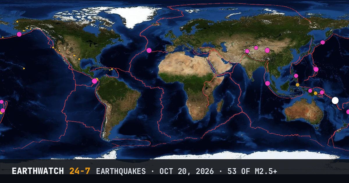
World map of the earthquakes on October 20, 2026

USGS recorded 53 earthquakes of magnitude 2.5 or larger around the world on Tuesday, October 20, 2026 (UTC). 24 were magnitude 4.5 or stronger, including 2 of magnitude 6 or more. The strongest was a magnitude 6.6 near Port-Olry, Vanuatu at 04:20 UTC. That is close to the average of 54 a day over the previous 25 days.

Earthquakes M2.5+53
M4.5 and up24
M6 and up2
StrongestM6.6
Deepest530 km
Most activeAlaska
See it on the live 3D globe →Watch live on YouTube🔔 Get alerts near you

Strongest earthquakes

By magnitude

M2.5 – 3.925
M4.0 – 4.918
M5.0 – 5.98
M6.0 and up2

Most active regions

Every earthquake

Time (UTC)MagDepthWhere
00:054.210 km28 km S of Goroka, Papua New Guinea
00:132.8158 km59 km ESE of King Salmon, Alaska
00:385.010 km205 km NW of Port-Olry, Vanuatu
00:564.510 km156 km SE of Kuqa, China
02:545.0129 kmPagan region, Northern Mariana Islands
03:052.914 km45 km NNE of Cruz Bay, U.S. Virgin Islands
03:442.816 km54 km SW of Adak, Alaska
04:206.610 km195 km NW of Port-Olry, Vanuatu
04:206.316 km197 km NW of Port-Olry, Vanuatu
04:462.827 km31 km SW of Chenega, Alaska
06:044.610 km7 km SE of San Julian, Philippines
06:073.25 km36 km ENE of Noatak, Alaska
06:295.210 km206 km NW of Port-Olry, Vanuatu
06:292.77 km16 km SSW of Jal, New Mexico
06:415.110 km263 km WSW of Yanglong, China
06:553.27 km20 km ESE of Pleasanton, Texas
07:094.9250 kmPagan region, Northern Mariana Islands
07:393.15 km80 km WNW of Ferndale, CA
07:522.811 km39 km SSW of Qualeys Camp, NV
08:394.910 km199 km NW of Port-Olry, Vanuatu
08:402.836 km5 km S of Volcano, Hawaii
08:402.740 km5 km SSW of Volcano, Hawaii
08:584.5418 km100 km SSW of Alo, Wallis and Futuna
09:332.713 km32 km SE of Bodie, CA
09:442.56 km45 km NW of Toyah, Texas
10:405.035 km81 km S of Sand Point, Alaska
11:404.910 km184 km NW of Port-Olry, Vanuatu
12:222.68 km16 km SSW of Jal, New Mexico
12:252.67 km16 km SSW of Jal, New Mexico
12:482.56 km15 km SSW of Jal, New Mexico
13:274.510 km142 km SSW of Abepura, Indonesia
14:204.557 km111 km S of Kokopo, Papua New Guinea
14:232.86 km17 km SSW of Jal, New Mexico
15:563.02 km22 km SSW of Lovington, New Mexico
16:232.50 km2 km NW of The Geysers, CA
16:295.076 km21 km SW of Meulaboh, Indonesia
16:294.8110 kmsouth of the Fiji Islands
16:312.834 km17 km SSE of Pāhala, Hawaii
17:055.410 km192 km S of Burica, Panama
17:184.510 km215 km S of Burica, Panama
18:024.235 km152 km WNW of Tobelo, Indonesia
18:075.110 km39 km W of Mosteiros, Portugal
18:122.7103 km88 km NNW of Karluk, Alaska
18:364.2354 kmsouth of the Fiji Islands
19:452.59 km20 km NW of Stanton, Texas
19:534.729 kmKuril Islands
20:034.910 km187 km NW of Port-Olry, Vanuatu
20:462.65 km11 km E of Pearsall, Texas
22:492.780 km27 km W of Salamatof, Alaska
22:514.310 km6 km SE of Pitaloza Arriba, Panama
23:164.666 km115 km NNE of Barishal, Pakistan
23:244.9530 kmsouth of the Fiji Islands
23:542.614 km24 km SSE of Maria Antonia, Puerto Rico

Data: USGS earthquake catalog, magnitude 2.5 and up, times in UTC. Outside the United States, USGS mainly lists quakes of about magnitude 4 and up, so smaller ones there are undercounted. Magnitudes and locations can be revised.

← Oct 19All daysOct 21 →