EARTHQUAKES · DAILY

Earthquakes on Sunday, October 25, 2026

Complete day, UTC
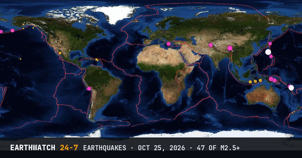
World map of the earthquakes on October 25, 2026

USGS recorded 47 earthquakes of magnitude 2.5 or larger around the world on Sunday, October 25, 2026 (UTC). 22 were magnitude 4.5 or stronger, including 2 of magnitude 6 or more. The strongest was a magnitude 6.5 in the Bonin Islands, Japan region at 02:09 UTC. That is close to the average of 54 a day over the previous 30 days.

Earthquakes M2.5+47
M4.5 and up22
M6 and up2
StrongestM6.5
Deepest569 km
Most activeAlaska
See it on the live 3D globe →Watch live on YouTube🔔 Get alerts near you

Strongest earthquakes

By magnitude

M2.5 – 3.919
M4.0 – 4.917
M5.0 – 5.99
M6.0 and up2

Most active regions

Every earthquake

Time (UTC)MagDepthWhere
01:352.71 km32 km WSW of Tecopa, California
01:465.110 km166 km WNW of Port-Olry, Vanuatu
02:065.110 km161 km WNW of Port-Olry, Vanuatu
02:096.5492 kmBonin Islands, Japan region
02:246.1116 km25 km ENE of Port-Olry, Vanuatu
02:364.8499 kmBonin Islands, Japan region
02:474.2500 kmBonin Islands, Japan region
03:295.281 km63 km NNE of Lae, Papua New Guinea
04:353.252 km58 km NNW of Charlotte Amalie, U.S. Virgin Islands
04:413.234 km65 km N of Culebra, Puerto Rico
04:513.429 km65 km NNW of Charlotte Amalie, U.S. Virgin Islands
04:582.826 km75 km NNW of Charlotte Amalie, U.S. Virgin Islands
05:113.144 km71 km NNW of Charlotte Amalie, U.S. Virgin Islands
05:154.910 km17 km SE of Ambelókipoi, Greece
06:044.553 km74 km SSE of Onagawa Chō, Japan
07:082.50 km38 km SSW of Dry Creek, Alaska
07:114.626 km50 km SW of Atiquipa, Peru
07:444.635 km82 km SSE of Akutan, Alaska
07:454.335 km81 km SSE of Akutan, Alaska
07:462.980 km35 km WNW of Kalifornsky, Alaska
08:415.410 km205 km NW of Port-Olry, Vanuatu
09:114.6133 kmVolcano Islands, Japan region
09:382.512 km12 km N of Powell, Wyoming
10:172.90 km166 km SSE of Old Harbor, Alaska
10:194.4233 km58 km N of Dompu, Indonesia
10:305.472 km33 km ESE of Ambunti, Papua New Guinea
10:322.910 km297 km WSW of Pelican, Alaska
10:342.834 km29 km E of Honaunau-Napoopoo, Hawaii
10:553.413 km85 km ENE of Christiansted, U.S. Virgin Islands
11:245.110 km199 km ENE of Nagqu, China
11:255.97 km218 km ENE of Nagqu, China
13:224.010 km7 km NNW of Agua Caliente Grande (De Gastélum), Mexico
14:152.53 km41 km WSW of Winthrop, Washington
14:312.710 km69 km SE of Yakutat, Alaska
16:103.1121 km39 km ESE of Cruz Bay, U.S. Virgin Islands
17:114.762 km19 km NE of Atico, Peru
17:445.2110 km59 km SW of Ashkāsham, Afghanistan
17:494.6153 km153 km WNW of Adak, Alaska
19:264.4127 km267 km WSW of Tual, Indonesia
19:542.73 km8 km W of Hallettsville, Texas
20:304.810 km167 km WNW of Port-Olry, Vanuatu
20:352.88 km18 km SSE of Meeker, Colorado
21:173.28 km69 km NE of Cruz Bay, U.S. Virgin Islands
22:014.710 km170 km ENE of Nagqu, China
22:145.3485 kmBonin Islands, Japan region
22:164.8482 kmBonin Islands, Japan region
23:324.3569 km181 km NNW of Maubara, Timor Leste

Data: USGS earthquake catalog, magnitude 2.5 and up, times in UTC. Outside the United States, USGS mainly lists quakes of about magnitude 4 and up, so smaller ones there are undercounted. Magnitudes and locations can be revised.

← Oct 24All daysOct 26 →